|
| The journey begins (registering before Katahdin) |
 |
| The Trail... on an ideal day |
 |
| First view from Katahdin |
 |
| More View from Katahdin |
 |
| This is the Appalachian Trail... some pull-ups required (also on Katahdin) |
 |
| Trail Magic! (also Katahdin) |
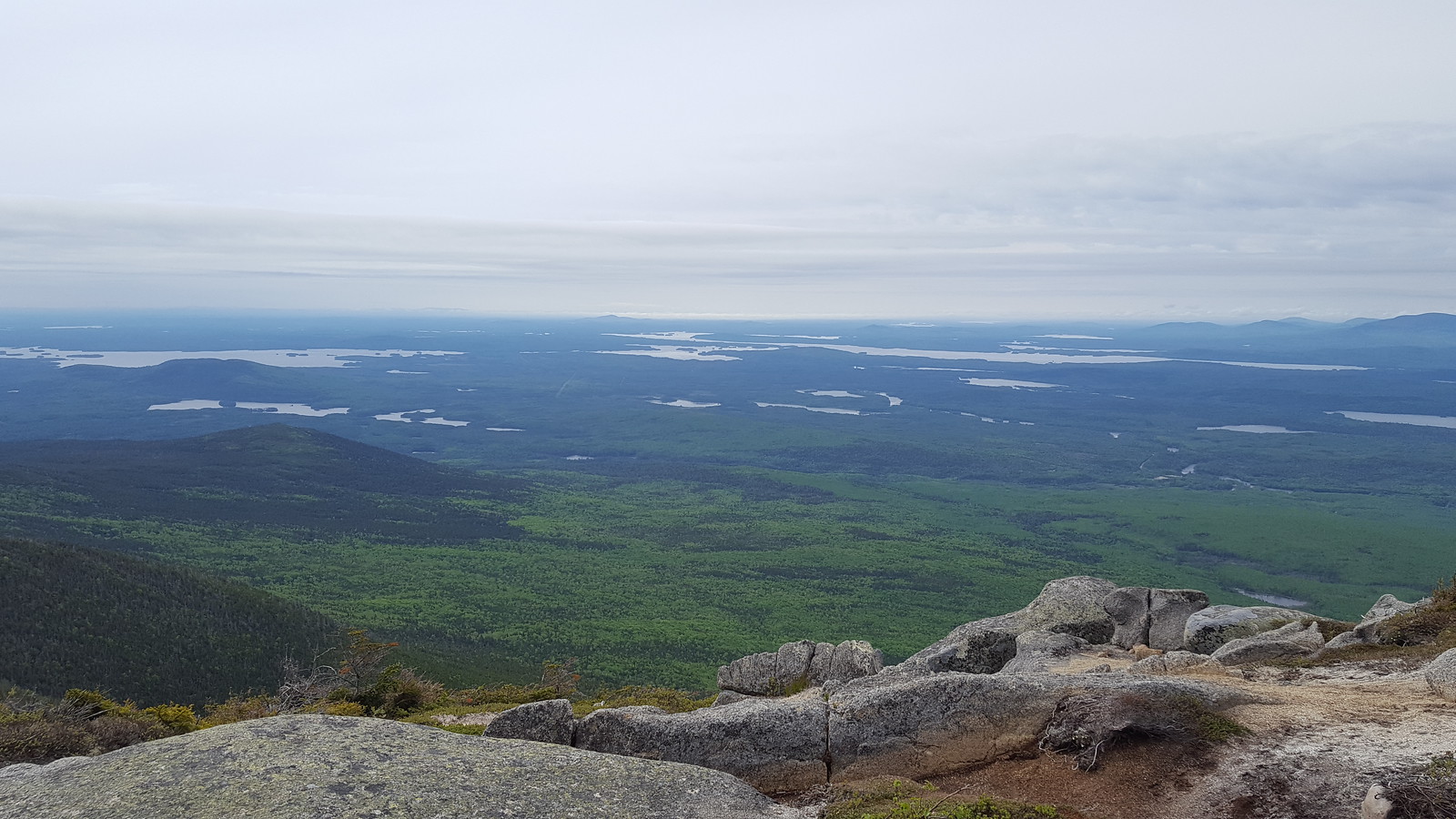 |
| View from Katahdin... only 2 miles left to go |
 |
| Is that the top? (Hint, it is... even though it's covered in clouds) |
 |
| Alpine Zones are fragile. Don't break. (Also Katahdin) |
 |
| The Peak... and the official start of the trail. |
 |
| Looking through the clouds (atop Katahdin) |
 |
| There's a lake below! (still Katahdin) |
 |
| Knife's Ridge... someday, I'll hike that. But not today. |
 |
| Plaque at the top of Katahdin |
 |
| More cloud covered Katahdin. Still has snow. |
 |
| It's a fording! I decided to take the high water bypass. |
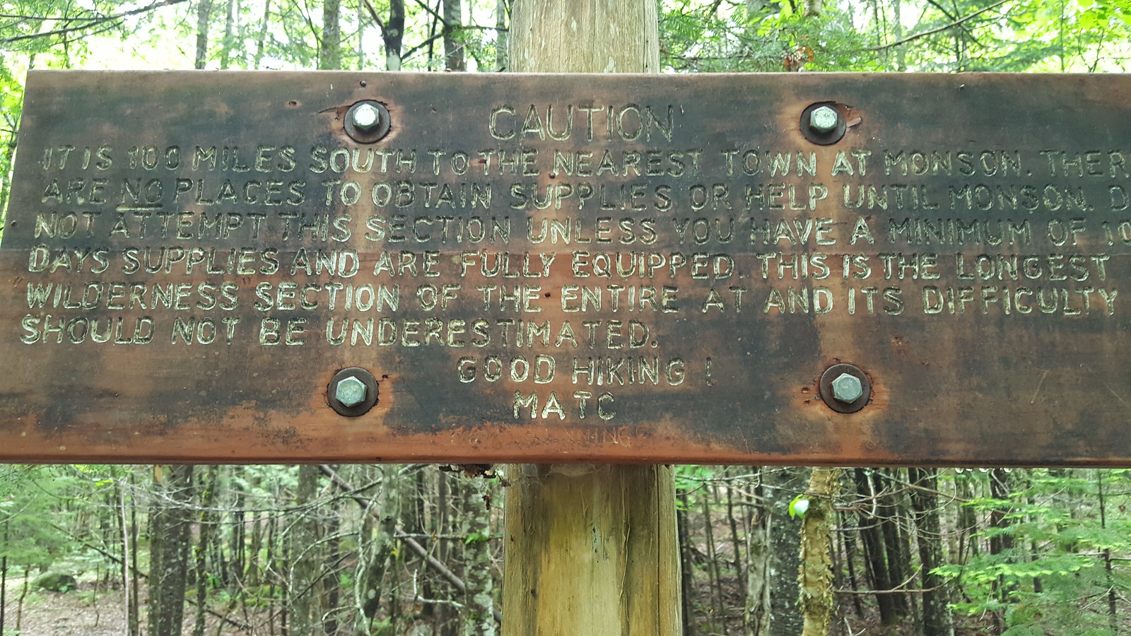 |
| 100 mile wilderness sign. Know what you're doing. |
 |
| A lean-to. Rainbo Stream Lean-to to be specific. |
 |
| Ideal Section of trail. |
 |
| Normal section of trail in northern half of 100 mile wilderness. |
 |
| 100 mile wilderness? Then why are there canoes? |
 |
| First good view on a clear-ish day. |
 |
| More rocky trail. |
 |
| Southern section of the 100 mile wilderness. Bouldering is fun. |
 |
| There's a bird! |
 |
| The clouds finally parted a bit! A good view. |
 |
| Mist covered mountain. |
 |
| Last picture before my phone broke, a mist covered lake from atop Barren Mountain. |
Now, with business out of the way, on to the journey!
Day 0 (June 5): Recap: Meet the SoBos
After arriving in Millinocket, I met five other Southbound hikers (SoBos). The Canadians (James and Tom), Casey, and Caroline. Casey had a four person lean-to reserved, and invited the Canadians and me to stay with him the first night, so I decided to do that and hike Katahdin. We chatted for a bit and plotted out our plans. Part way through the night, we recieved our first omen, when another SoBo got a ride out of the 100 mile wilderness after giving up on day 3. He told us all about how bad the trail was, how you couldn't sleep at night, and how you needed hiking poles (which none of us had). Our spirits were undamped, but we considered ourselves warned.
Casey decided I should be called Grizzly because I've got a huge red beard and am from California. We'll see if it sticks (turns out it does).
Hours in boots: 0
Water drunk: 2 liters
Injuries sustained: 0
Food consumed: 4000 calories
Bunked with: Casey, Caroline, The Canadians (Tom and James)
Casey decided I should be called Grizzly because I've got a huge red beard and am from California. We'll see if it sticks (turns out it does).
Stats:
Miles walked: 0Hours in boots: 0
Water drunk: 2 liters
Injuries sustained: 0
Food consumed: 4000 calories
Bunked with: Casey, Caroline, The Canadians (Tom and James)
Day 1: Katahdin
The other SoBos and I took a ride with four others from the AT Lodge down to Baxter State Park (where Katahdin, the northern terminus, is) to climb Katahdin at 6:30. We met with the ranger and left our heavy (~50 lb) packs there, took daypacks (<5 lbs), and started our climb. The ranger told us to expect it to take 8-10 hours to climb Katahdin.
The climb was beautiful. It was a partly cloudy day, which meant we were walking through a forest in and out of shade. The trail paralleled a stream (with waterfall) for quite a while, and occasionally the stream would overlap with the trail, making the trail essentially a rough water slide (which was fun to walk up).
After about 2 miles of incline, we got above tree-line, and hit the boulders and wind. This was where the fun really began. The trail transitioned into rocks and climbing. Some sections had rebar hammered into the mountain to allow people to climb, and at one point, you had to do a pull-up (on a pull-up bar) to continue your climb. During all this time, there were gusts of up to about 40 mph. For those who hiked with me in Arizona, the terrain was similar to the rockiest sections of four-peaks and flat-iron, but lasted about 2 miles.
Once you finished the rock climbing, you climbed a false summit, and could finally see the top, or so I was told. The partly cloudy day I started with became a full-on cloudy day, and I couldn't see the top of the mountain, because the clouds were swirling around it (I got some pretty epic pictures on my now broken phone).
Once at the top, I got a picture at the northern terminus sign (though I lost the picture now because phone), took some pictures when the clouds slightly parted, and headed back down them mountain.
I booked it down the mountain and was having fun jumping down from rock to rock, when I reminded myself I was going to need to hike the next day, so tried to take it slow and not get hurt. I was successful. I got down the mountain just under 6 hours after I started (I was quite proud).
I considered going down the AT some more, and leaving Baxter State Park, but decided I'd stay with Casey and the Canadians, and just hike extra far the next day. So I set up my hammock and tarp and bugnet, made my Mac n Cheese n Tuna, and ate and hung out until they showed up. We got a fire going, and had a grand old time (until the Ranger told us we were too loud and there were families near by).
I believe the Canadians finished Katahdin in about 7 hours, and Casey and Caroline finished in about 13 hours.
Stats:
Miles walked: 11
Hours in boots: 6
Water drunk: 3 liters
Injuries sustained: 10? Mosquito bites
Food consumed: 5000 calories
Pot: burned Mac n Cheese scraped out of bottom, some residue left, hammered out with rocks
Stayed with: Casey and The Canadians (Tom and James)
Hours in boots: 6
Water drunk: 3 liters
Injuries sustained: 10? Mosquito bites
Food consumed: 5000 calories
Pot: burned Mac n Cheese scraped out of bottom, some residue left, hammered out with rocks
Stayed with: Casey and The Canadians (Tom and James)
Day 2: Solo Sobo
It rained in the night. Hard. Undeterred, Casey, the Canadians, and myself all got up early (4:30 AM) to start our hike. They were planning on hiking 13-ish miles to the end of Baxter State Park, and I was planning on hiking 21 miles to Rainbow Spring Campground.
I accidentally knocked over my boot in the night, so my right hiking boot was filled with water from the start. Fortunately, I have an extra pair of socks, so I just switched out my right sock after mile 3 and mile 7 to prevent badness. Unfortunately, my boots are nowhere near as waterproof as they were when I bought them 6 years ago, everything was wet, and my plans were too ambitious.
I made fairly good time at first, and got out of the park at noon (I left after the Canadians and Casey, but they got lost, so I wound up getting out first). Hiking on my own was nice, I got to set my own pace, stop when I wanted, see what I wanted, take pictures where I wanted. I eventually got to a fording, but upon seeing I couldn't safely rock-hop across it (I'd have needed to take off my boots to ford), I took the highwater bypass (which was also quite nice).
I met a couple people on the trail, but was largely alone. By a little after noon, I reached the end of Baxter State Park, which had a store (where I bought delicious calories in the form of a ham sandwich and a huge muffin). According to the campstore owner, there were a lot of SoBos this year, he estimated he'd seen about 50 pass in the past week (since people started being able to hike south). Apparently I'd be meeting some people.
I crossed the bridge and entered the 100 mile wilderness, passing a faded and worn sign warning hikers that there is no chance of resupply, and they should all have at least 10 days of food with them, and they'd better know what they're doing because help won't be on the way. It was a good sign. 3 miles down the trail, I met some people hanging out with their dog, taking a zero day (aka a day where you don't hike), and drying their gear from the night before. I stopped and chatted with them, apparently there was a huge group of SoBos here the night before and they had all left this morning, this couple had decided to stay behind today so they weren't caught in the huge group.
Moving down the trail, I met Dee Do It, a cancer survivor finishing his northbound thruhike (he was forced off the trail last year because of cancer, and now is back to finish it... then hike it all south). Once he hits Katahdin, his trail name will change to Dee Done It. I offered him some trailmix (he was low on food) and chatted with him a bit, when he was sad I didn't have a trail name, I offered Grizzly as my name, which comforted him a bit.
I continued hiking, climbed a mountain, and saw Katahdin in the distance (still behind clouds), when a ridge-runner met me. A ridge-runner is apparently someone who works on a section of the Appalachian Trail. They hike the same section over and over cleaning up the shelters people stay at, fixing up the privies, taking junk people leave on the trail off, and taking care of people. She was very nice and sociable, I left her on the mountain and continued on to my campsite, which was 5 more miles away.
I should note right now: my feet were in pain. I've done hikes this long before, but did them in Arizona, where my boots were dry. At this point, I'd been hiking for 12 hours in wet boots, and had not taken my socks off since I got to Baxter State Park (an INCREDIBLY bad decision). I could tell I had some sort of blister thing on almost all my feet, and also on the balls of my feet. Even the tops of my toes hurt. Every step was agony.
Eventually, I could take it no longer, and changed into my flip-flops 2 miles out from the campsite. I figured I've hiked long distances in my flip-flops before and my feet were killing me. When I took my socks off, my feet were very happy about that, but still hurt. Also, I did not account for something: Maine. The AT in Maine can be fairly well summed up by three words: Rocks, Roots, Mud. Everywhere on the trail had plenty of each. So, within about 0.2 miles, I took a step across a boggy section and broke my left sandal. By this point the Ridge runner had caught up with me, so I changed my left sandal into my left boot and kept going (with one boot and one flop). About 1 mile out from the campsite I slipped (it's really hard to keep track of which foot has traction and which doesn't), and ripped my left armsleeve of my shirt. It was unfortunate.
Eventually, I stumbled into camp, washed my foot-sores, cooked food with a headlamp, hung my bear-bag, begged off some duct-tape from a hiker staying at the site, and stumbled into my hammock. Moxey suggested I sleep with my socks to dry them. I also hung my boots under my hammock tarp so they wouldn't get wet if it rained. I was exhausted.
Stats:
Miles walked: 21Hours in boots: 13
Water drunk: 6 liters
Injuries sustained:
30? Mosquito bites
Unknown swollen paper-like skin condition on both feet
Blisters:
Left heel
Left pinky toe (bottom)
Left fourth toe (bottom)
Ball of left foot
Left big toe (bottom)
Right heel
Right pinky toe (bottom)
Right fourth toe (bottom)
Ball of right foot
Right big toe (bottom
Bleeding Sores:
Left pinky toe (top)
Left fourth toe (top)
Right pinky toe (top)
Broken equipment:
Shirt (left arm ripped)
Left sandal strap broken (temporarily fixed with a strand of duct-tape)
Food consumed: 7000 calories
Pot: burned Mac n Cheese on bottom, gave up as tired and threw in food bag
Stayed with: Moxey (trail runner), Noah (gave me duct-tape), Unknown NoBo
Day 3: Join the Group
The next day, I was hurting. My feet still looked like I'd been in a Jacuzzi too long, my blisters were popping, my sores were bleeding, but I wasn't going to take a zero on my second day alone! I'll just hike a little bit. Maybe 12 miles? So I spent about 30 minutes bandaging up my feet, then put them back in my boots, packed up and left. Though I slept in, so everyone else had already left, and I hit the trail about 8:30 AM.
The first couple miles were pretty good, I made good time, and got the the Rainbow Stream Lean-to, where I could tell Moxey had her work cut out for her cleaning up after some SoBos (a big group had stayed there the night before). I just kept going, I'd only gone about 3 miles, but my feet were starting to hurt.
I made it another 5 miles, and I met people on the trail! I was super excited because they were the first people I'd met going south on the trail, so I stopped and said hi to them and their dog. They were planning on going to the next shelter, where I was considering stopping (if my feet continued to hurt).
Eventually, I passed another 3 or 4 people, but my feet were beginning to really hurt, so I slowed down and some of them passed me. I finally hobbled into the shelter at about 3 PM and decided I'd stay there the night -- there were about 15 people there, and they had fire. The fire was made by a hiker named Pyro (apparently not the first fire he made), who turned out to be the same Alex who had given me a ride from Baxter! It was fun to see him again.
At Cave-girl's suggestion, I put my feet up by the fire for a couple hours because she thinks the wrinkled paper-like skin condition I have is from my feet being wet. It felt very good, so she was probably right. I stayed and chatted all night.
Stats:
Miles walked: 12Hours in boots: 6
Water drunk: 4 liters
Injuries sustained: 20? mosquito bites
Injury status change:
Unknown swollen paper-like skin condition on both feet identified as probably from wet feet.
Feet still hurt.
Food consumed: 6000 calories
Pot: third layer of burned Mac n Cheese on bottom, realized my pot will never leave my food bag
Stayed with: Big-ole group of SoBos
Day 4: Burgers and Pizza!
That night around the fire, talk was had about a place called "White House Landing" on the trail. Apparently it's a place you can stay on the trail if you want to be in a cabin, and they also serve food --> giant burgers and pizzas. We all hiked the next day with "Burgers and Pizza!" as our chant.
I again slept in, bandaged my feet, and hit the trail around 8:50 AM. I think I was the last person out of the campsite. That said, although my feet may be killing me, my legs are still in good shape from the preparation I did, so I passed about 10 people in the first couple hours. Unfortunately, after about hour 3, my feet started demanding I do something (preferably take them out of boots), which slowed me down substantially. I managed to motivate myself with the promise of burgers and pizza (and somewhere dry I could have my feet out).
At mile 8, we hit the sign for White House Landing, it was just 0.2 miles off the trail: totally worth it. So we hiked down the mosquito infested marshy path to the landing, where we promptly found out we needed a reservation. Apparently the owners live in Bangor and only come out occasionally (they weren't out today), so we had no chance of getting anything from them. It was a disheartened and saddened group which returned to the AT and sat in the mosquito hunting grounds and ate our trail-mix (or re-bandaged and socked our feet in my case). Then continued on the 2.6 miles to the next shelter.
By the time we got to the shelter, my feet were on fire, and I switched into my camp sandals. Eventually, someone took pity on my zombie-shuffle and re-duct-taped my sandals more securely (I regret not bringing duct tape).
That night, several other hikers came and passed our group, including the Canadians who had caught up with us. They decided to go swimming in the creek (after all, the outside temperature was about 40 F and the water was maybe 45 F). We all decided they were crazy, though one of them earned the trail-name Aqua (by this point, my trail name had been established as Grizzly).
I dried all my footwear (boots and socks and feet) by the fire, and suddenly it didn't hurt to walk anymore! This was excellent news, and I decided I'd take advantage of it the next day by hiking with the earlier (and probably faster) hikers. I talked with Pyro and some of the other faster hikers in the group, I wanted to get up early, and heard some people describing themselves as "the badass squad." Turns out, they were all sleeping near where I'd set up my hammock, so we all decided to go together (Moose, Elsie, Peaches, Karate-Kid, and myself) at 6 AM the next day. We planned to go farther than the rest of the group was planning on going.
Stats:
Miles walked: 10
Hours in boots: 5
Water drunk: 3 liters
Injuries sustained: 60? mosquito bites
Injury status change:
Swollen paper-like skin condition on both feet treated successfully with fire
Blisters on toes, balls of feet, and heels gone with paper-skin condition, open sores remain
Feet still hurt.
Food consumed: 5000 calories
Pot: Hammered out burned Mac n Cheese with a thick stick, only has one layer now (and many scorch marks)
Stayed with: Moose, Elsie, Karate Kid, Peaches
Hours in boots: 5
Water drunk: 3 liters
Injuries sustained: 60? mosquito bites
Injury status change:
Swollen paper-like skin condition on both feet treated successfully with fire
Blisters on toes, balls of feet, and heels gone with paper-skin condition, open sores remain
Feet still hurt.
Food consumed: 5000 calories
Pot: Hammered out burned Mac n Cheese with a thick stick, only has one layer now (and many scorch marks)
Stayed with: Moose, Elsie, Karate Kid, Peaches
Day 5: The Badass Squad
The Badass Squad consisted of three groups. Kayla "Moose" and Elsie (no trail-name) are two recent college graduates who decided to hike the AT together --> Moose had basically asked a bunch of people and Elsie decided she wanted to do it. Cannon "Karate-Kid" is a 19 year old guy who had just finished community college and was about to go into a four year college for his B.S. Andrew "Peaches" is a 23 year old guy who, like me, had just quit his job and wanted to do something fun, so went on the AT. Aside from Moose and Elsie, they were all solo, and had just met days earlier and hiked together.
We all got up in the morning, and things started to go south about 5 minutes before we hiked. I decided to wash my bandanna, but slipped and stuck my left boot right into the river. Peaches gave me his towel, and I dried it as best I could, and changed into a dry sock, but I was terrified my foot my get whatever it was again.
Undeterred, we set off about 5 minutes late, with Karote Kid leading, and myself right behind. Eventually, I took the lead (there were a bunch of rocks when I love going fast on). Eventually, I realize I can't hear their trekking poles (everyone aside from me had a pair of hiking poles), so go back to look for them. Moose had taken a fall and hit her elbow pretty bad, but they were going by the time I got to them.
After about a mile, we realize Moose's arm is really messed up. She couldn't feel it below her elbow, and it was getting red and swollen -- most of the time she was using her other arm to hold it in place rather than use her hiking pole. We made a makeshift sling for her (none of us actually knew how to make one) out of two bandannas and made her take a bunch of Ibuprofen (she had never taken it before and didn't want to take any medicine).
Two miles later, we got to where Karate Kid had a food drop (he took half his food with him, and had a company put it in a bear canister about half-way through the wilderness). Unfortunately, the food was not there, and he had no way of contacting the company (since nobody had any reception). We also gave Moose 8 more Ibuprofen before climbing the mountain.
Then we climbed a mountain for about two miles, where Karate Kid finally got reception. He called the company, which apologized and told him they gave him the wrong directions. They texted him the new directions. It was 3 miles back down the trail (and down the mountain we had just climbed). Karate Kid went back down to get his food, and we continued on.
Peaches and I were in the front, when we realized we couldn't hear Elsie or Moose behind us. Eventually we hear Elsie shouting for Peaches, and we go back. Moose had fallen on her elbow again. We gave her a couple more Ibuprofen, and each took about 5-10 lbs from her pack so she didn't have to carry as much. We then continued our decent to the next mountain climb.
Eventually, we hit the shelter which was supposed to be half-way to our minimum goal. Peaches and I started to set about setting things up for Moose and Elsie so they could stay as we pushed on, but Moose decided she wanted to come with us. Since we had some down-time, I found some good wood and made a make-shift splint for her (again, none of us knew what we were doing), which was marginally better than the make-shift sling we'd made (it kept sliding off).
We got back on the trail.
1.5 miles from our goal, Peaches realized he ran out of water --> also, by this point, I was the only one in the group who still had a functioning water filter (their pumps had clogged and broken). We found what appeared to be a sewage pipe, and filtered and medicated it (put purification tablets in it) and hoped it wouldn't kill him, then continued our climb (it was 1.5 miles with a 1000 foot elevation increase).
We eventually made it into our shelter. A couple people from the big group had gone on, one (Tarzan) was still there, and most hadn't gotten there yet. As we were the first ones there, we took our hiker rights and slept in the shelter like lazy people. It felt good to be lazy. I was just glad my feet hadn't gotten any of the problems they'd had for the days before.
Stats:
Miles walked: 10
Hours in boots: 10
Water drunk: 6 liters
Injuries sustained: 30? mosquito bites
Blisters on heel of both feet
Feet still hurt (but not as much).
Food consumed: 6000 calories
Pot: Elsie made Mac n Cheese. Burned Mac n Cheese on bottom, threw pot in food bag after others figured out they couldn't clean it
Stayed with: Moose, Elsie, Karate Kid, Peaches, Tarzan
Hours in boots: 10
Water drunk: 6 liters
Injuries sustained: 30? mosquito bites
Blisters on heel of both feet
Feet still hurt (but not as much).
Food consumed: 6000 calories
Pot: Elsie made Mac n Cheese. Burned Mac n Cheese on bottom, threw pot in food bag after others figured out they couldn't clean it
Stayed with: Moose, Elsie, Karate Kid, Peaches, Tarzan
Day 6: Good Views and Climbs
With the next day, Moose could now move her elbow about 10 degrees without pain, so she decided she wanted to press on. So we did. We climbed the 1200 feet over 1 mile that was right after our shelter, and then the mountain range after it. It was finally not cloudy for once, so we got some pretty great pictures at the top. We also met the New Yorkers (Joey and Ivan), and Joey had wilderness survival first aid, and knew how to make an actual sling! So we made a sling for Moose's arm, which seemed to help. Though she was worried because we had heard there was rock climbing we'd need to do the next day, so she decided she'd take it off to try to get more range of motion.
Eventually, our group separated slightly (Karate Kid got to our destination about 2 hours before the rest of us). Peaches and I kept waiting for Elsie and Moose (Elsie was having a hard time with all the elevation gain, and Peaches and I don't trust Moose's evaluation of her own well-being). Somewhere along the line, we met Tazer and Firehugger, a couple hiking the AT which is going for longest thru-hike (they've been in the 100 mile wilderness since May 22). They were taking a zero since Firehugger had popped her knee out of place, but she'd just popped it back in and was chucking trees around making a fire and cooking bread (it was very impressive). She was also a wilderness first responder, which means she knew even more stuff about what our problems were. She identified the foot problem I'd had as Trench-foot, a WW1 disease which soldiers get which causes permanent nerve damage to your toes. Fortunately, I can still feel my toes (unlike Moose and her arm). She also took a look at Moose's arm and basically said, "That's weird. You should definitely see a doctor when your out, but we can't really do anything. Try not to move it." At this point, there's just a section of her forearm she can't feel, and it hurts to move her elbow. She started using her hiking poles.
We eventually reached the end of our hike late (about 5 or 6 PM) and had a river to ford (about 150 feet of walking barefoot across the river) to get to our campsite, where we all sat in a circle and cooked our food. By this point, my pot has become an inside joke as the mac n cheese I cook is almost literally impossible to remove from the bottom, and I carve a stick each night to stir it. That said, nobody else has had any luck when they've tried to "show me how to cook." I traded Elsie some Mac n Cheese for some Ramen. We met up with the New Yorkers at the campsite.
Stats:
Miles walked: 11Hours in boots: 10
Water drunk: 3 liters
Injuries sustained: 20? mosquito bites, 5? fly bites
Feet hurt a little
Food consumed: 6000 calories
Pot: Additional layer of burned Mac n Cheese on bottom, threw in food bag, offering mac n cheese to friends as a joke.
Stayed with: Moose, Elsie, Karate Kid, Peaches, Tarzan, New Yorkers
Day 7: Here Comes the Rain (Again)
After decided we'd get up early to try to go over the entire next mountain range, I was the only one who got up at a decent time (i.e. before 5 AM). So I started taking down my hammock. Now, I have two ways I take down my things: when it's raining (leave the tarp up until the end) and when it's not raining (taking everything down at once then pack --> it's significantly faster). As it wasn't raining, I just untied everything and started packing. About 1 minute after I packed my tarp, it started raining HARD. As my sleeping bag, hammock, and bugnet were out, and my bag was open, everything got wet except for the things I keep in ziplock bags (which included a pair of socks), my boots (which I threw underneath my pack at first sight of rain), and my food (which is ALWAYS in a dry-bag, because wet food is disgusting). Everyone else was happy in their tent.
When it became apparent the rain wasn't going to stop, I continued packing things up in the rain (and everyone else started packing in their tents). Today Elsie and Moose split ways (Elsie wanted to take a zero day, Moose wanted to continue on with us). We climbed in the rain. Everything was wet. Karate Kid and Peaches both snapped a hiking pole. Everyone fell several times (though there were no serious injuries, just bruised hips and knees). We got to the second shelter, but didn't make it to our third and down the mountain, because we didn't want to go over the ledges Tazer warned us as slippery while there was a deluge of rain. Instead we stayed at Cloud Pond --> which was a pond, in a cloud.
It was cold (my thermostat read about 40 F, gusts must have been at least 40 mph, and it kept raining). We slept in the shelter because we were lazy, and met up with the Canadians.
Stats:
Miles walked: 8Hours in boots: 10
Water drunk: 2 liters
Injuries sustained:
Blisters on hips from pack
Food consumed: 5000 calories
Pot: Tired and cold and didn't cook. Internally given up hope on ever having a clean pot again.
Stayed with: Moose, Karate Kid, Peaches, Tarzan, New Yorkers, Canadians
Day 8: Almost..... There.....
The next day, the Canadians left early (about 4:30), but the rest of us slept in (it was cold). Eventually we left the shelter around 9:30 AM to go down to mountain. Peaches' feet were getting infected, so he said probably bye to us when we left (since he was going to need to take it slow).
On the top of Barren Mountain, I managed to find a cell tower for the first time and called my parents and posted a ridiculous selfie on Facebook (ridiculous because it's like <40 F, gusts of 30+ mph, and I'm in the middle of a cloud). I suspect this may have been what ruined my phone. The next time I pulled my phone out to take a picture, it had a blue downloading screen, and was non-responsive. Since I've been in town, it's been unable to charge. But here's the one picture I have from the 100 mile wilderness.
 |
| Top of Barren Mountain, right before my phone died. It's cold. |
Turns out, Moose, Karate Kid, Peaches, and myself each gave up at the same spot at 2:30 PM, about 10 miles away from the exit of the 100 mile wilderness, so we wound up spending the night in the shelter there: though at the New Yorker's suggestion from the night before, I set up my hammock in it (sleeping in a hammock is far more comfortable than sleeping on a wood floor). A couple SoBos passed us, and continued on, but we hadn't met any of them before. Eventually, a father-son pair of weekend hikers came to the shelter, we offered them a spot. After failing to set up their tent in the rain, they decided to take us up on that offer. They were fun, and we eventually gave the son the trail name Ice Hot.
Stats:
Miles walked: 8Hours in boots: 6
Water drunk: 3 liters
Injuries sustained: 10? mosquito bites
Deep scratch on left hand from fall
Bruised right hip from fall
Food consumed: 6000 calories
Pot: Cooked Ramen in Karate Kid's pot. Trying to ignore my pot's stench.
Stayed with: Moose, Karate Kid, Peaches, Ice Hot, Ice Hot's dad
Day 9: Monson!
This was the day! We were going to make it to Monson and civilization, we only had 10 miles to go, and we got up early to make it. We woke up at 4:30 and left the shelter by 6:30 (we were delayed because we had to filter all our water through my filter and we tried not to wake up Ice Hot or his dad). Unfortunately, this was also the day all our injuries flaired up. Karate Kid was largely fine, his knees hurt and he'd broken a hiking pole, but he was ok. Moose wasn't using her left arm and had broken a hiking pole the day before. Peaches' heels were a mess of blood and infection. I was fine to start.
While it was only 10 miles, there were two fordings we had to do (I fell into the river on one of them). Also, about 5 mile in, I either pulled something or got a terrible cramp (never figured out which) in my left foot which made each step agony. But, we all eventually made it (with a couple more falls a scraps --> I now also have two shallow cuts on my left hand), and hitched a ride into Monson.
We had a nice supper, where Peaches and I each had a burger as appetizers and then split a large pizza. After that, we chilled in our respective homes (Peaches and I are staying at the Lakeshore Inn & Pub, most of the hikers are staying at Shaw's --> I picked the Pub because they have a loaner laptop).
Stats:
Miles walked: 10Hours in boots: 6
Water drunk: 3 liters
Injuries sustained: Twin scratches on left hand from fall
Food consumed: 6000 calories
Pot: In trash can.
Stayed with: Civilization and bedsheets
Zero Day!
Today, we've taken a zero day, which means no hiking. All our sores are healing, Moose's elbow is just about fixed (she decided not to go to a doctor), Peaches is limping less (his heels are still a bloody mess, but at least they aren't infected), and the New Yorkers have basically said they want to hike with us (they decided to take a zero today when they heard we were). We've done our resupply (I got a new pot and different food and a rope (I lost my old one), seen how much weight we've lost (Peaches lost 21 lbs, I lost 15 lbs (though I gained it back after my first meal, so I'm mildly suspicious I just misread the scale)). We've heard news about other groups we met who are ahead and behind us, have relaxed and had fun and are ready and excited for our continuing adventures tomorrow.
Blessings,
David "Grizzly" Martin